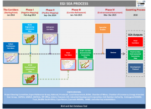
The SEA process is separated into various phases:
Preliminary Corridors
Phase I
Phase II
Phase III
Phase IV
Gazetting Process
- Preliminary Corridors
Preliminary Corridors are the starting point of the SEA. The corridors were identified by the Strategic Gird Planning Division of Eskom and are based on the results of a detailed Eskom Strategic Grid Plan Study. The study considered a number of possible future generation and load scenarios, and in so doing, identified the need for five national transmission infrastructure corridors to facilitate the balancing of South Africa’s electricity supply and demand needs up to 2040. The three scenarios considered were the Integrated Resource Plan 2030 base line scenario, an increased renewable scenario, replacing the nuclear component of the IRP with Concentrated Solar Power and battery storage capabilities and finally the increased imports scenario which assumed a doubling of electricity imports from neighbouring countries by 2030. The five corridors identified satisfy any of the three scenario outcomes and any combination thereof.
The corridors are:
- Western Corridor – along the west coast of the Cape.
- Eastern Corridor – along the east coast of the Cape and KwaZulu Natal
- Central Corridor –from the Western Cape via the Northern Cape and Free State to Gauteng
- Northern Corridor – from Northern Cape to the North West Province
- Import Corridor – from Limpopo down to Gauteng and Mpumalanga.
- Phase I (Constraints/Negative Mapping)
involved a wall to wall sensitivity delineation assessment to determine areas where electricity grid infrastructure is likely to have a negative impact on the environment (environmental constraints) and areas where the environment is likely to have a negative impact on electricity grid infrastructure (engineering constraints). Environmental constraints include (but are not limited to) sensitive features such a protected areas and heritage sites as well as existing and conflicting land uses, such as the Square Kilometer Array and aerodromes. Engineering constraints include, and are not limited to, steep slopes and areas with restricted road access. The full extent of South Africa was then graded and mapped for environmental and engineering sensitivity, indicating areas to be avoided (Very High sensitivity), to areas which are sensitive for various reasons (High-Medium sensitivity), to areas which demonstrate no sensitivity (Low sensitivity). The outputs of Phase Ia are a Wall-to-Wall Environmental Constraints Map and Wall-to-Wall Engineering Constraints Map. The
- Phase II (Utilisation/Positive Mapping)
involved the identification of areas within and immediately adjacent (a maximum distance of 25km) to the preliminary corridor boundary where transmission infrastructure would be best utilized, both from a electricity generation and load perspective. The process involved identifying areas of highest planned and potential generation and load activity. Information was sourced through a detailed review of provincial and local government spatial development planning documentation as well as through consultation with government and industry. The outputs of this exercise were then digitized to develop the Final Utilisation Corridors i.e. 100km wide corridors which represent where future transmission infrastructure might be best utilised.
- Phase III (Corridor Refinement)
involved aggregating the digital information captured in Phase I to determine optimal placement of the final corridors from both a ‘utilisation’ and ‘constraints’ perspective i.e. where utilization is maximized whilst ensuring suitable transmission routing alternatives are available from a constraints (both environmental and engineering) perspective. Where either partial or complete pinch points exist within the Utilisation Corridors, the Corridors were polarized, where possible, in the direction of adjacent relief. The outputs of this exercise were the Final Corridors and Draft Corridor Environmental Constraints Map.
- Phase IV of the study involved specialist studies.
Specialists were required to review, validate and enhance the sensitivity delineations, for their particular specialist area of expertise, defined within the Draft Corridor Environmental Constraints Map. Furthermore specialists will be required to recommend what additional information/ level of assessment should be undertaken within different sensitivity areas before environmental authorisation for electricity grid infrastructure development in these areas can be considered. The results of the study study have been used to inform the final sensitivity maps as well as the Development Protocol. Environmental aspects assessed by specialists included, terrestrial and aquatic biodiversity, heritage, visual impact, birds, agriculture and socio-economic. Sensitivity maps have also been developed for defense, civil aviation, mining and Square Kilometer Array which were informed by the relevant authorities.
- Gazetting Process will be managed by the DEA once the SEA has been completed.
The outputs of the SEA will be released for public comment through publication in the Government Gazette. The gazetting process is envisaged to take place in 2016.

